See Your Region’s Future with Synthetic Modelling
Visualize multiple future scenarios in one information-rich environment.

Visualize multiple future scenarios in one information-rich environment.
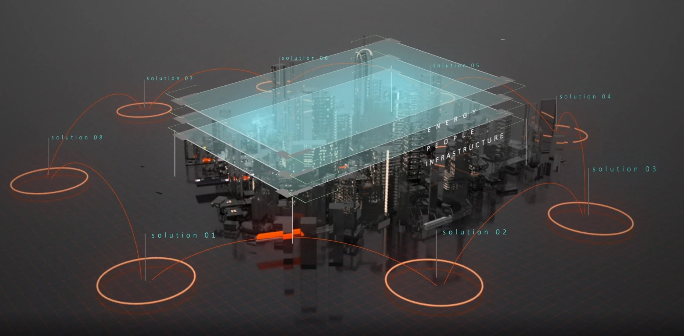
Municipal governments can see potential future outcomes for their region using RWI’s synthetic data platform. RWI helps municipal and regional leaders answer a wide variety of questions related to operating complex environments.
Successfully modelled and visualized scenarios include:
Designing better transportation infrastructure
Enhancing micro and active mobility and public transportation (ie lrt,...)
Detailing the phasing and incentive response of decarbonized energy resources (ie solar, community storage…)
Collaborating around growth planning including social, economic, and environmental changes
Analyzing the benefits of different urban egress options in the case of disaster (e.g., wildfire)
Visualizing the future of economic sectors (e.g. hydrogen production) in terms of supply, demand, transportation, infrastructure, and workforce
Calculating the resilience, emissions, and equity impact of distributed energy systems
Optimizing resilience, mitigation and response planning for climate change, natural disasters, and power outages
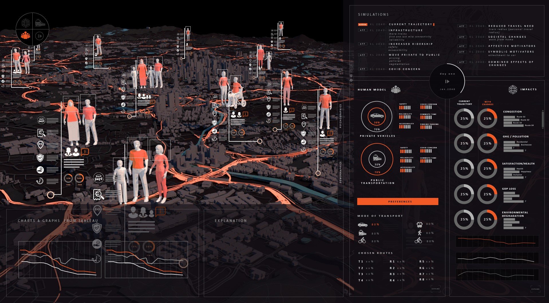
Each “live” visualization allows decision makers to interact and see the effect of introducing variables into a hyper-realistic, quantifiable environment. Decisions can be acted upon with certainty as you model scenarios for:
Urban planning
Investment attraction
Disaster planning
Social program creation
and much more.

Click to view some of our sample projects.
Recently RWI initiated a project in a metropolitan region (MR), whose hub city was surrounded by 35 census sub-divisions with over 1.3 million people. To encourage the MR municipalities to co-operate as a region, the provincial government mandated that the MR coordinate land-use and infrastructure planning for its principal municipalities. Regardless of the establishment of the mandate, several practical realities existed to achieve genuine cooperation amongst its participants.
Read how RWI helped win collaboration amongst the principals, even with diverse and sometimes competing objectives.
Synthetic Modelling incorporates open, publicly available data into RUNWITHIT’s state-of-the-art proprietary modelling technique to create models that generate Synthetic Data.
Generated results and data are unbiased, without the inherent limitations of surveillance constraints or events without precedent. We can fill the gap where data may be missing or unobtainable, constrained by regulatory and privacy concerns and move forward to complete key datasets.
By combining multiple diverse sources and expertise and synthesizing surveys, forecasts, and incomplete data using neural nets and filtration techniques, Synthetic Modelling enables more complete data than exists today, and realistic, sophisticated data from the “what if’s” of tomorrow.
We work with leaders all over the world. These partners are individuals or groups who are driven and innovative decision-makers, responsible for the success of critical infrastructure that shape futures.
Upon submission, our team will reach out to you in 2-3 business days.


